Transmission Line Development Near Aerodromes

Introduction
The development of large scale wind and solar developments throughout the world means that new overhead transmission lines are sometimes routed near existing civil and military airbases which can result in aerodrome safeguarding objections due to collision risk or the potential impact on radio and electronic navigation aids.
Pager Power recently undertook a safeguarding assessment for a proposed new transmission line in the vicinity of a military airbase in Africa[1]. The diagram below shows the runway, a 4 nautical mile radius around the base and the proposed transmission line route. The spacing between gridlines is 1 kilometre.
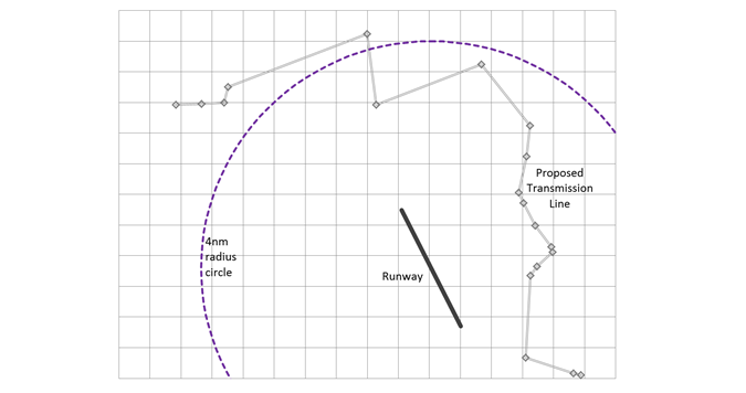 Figure 1: Runway, 4 nautical mile radius and proposed transmission line route
Initial Discussion
The project developer explained that the military authorities were objecting to the proposed transmission line because it passed within 4 nautical miles[2] of their largest airbase with the lines presenting a potential collision risk to fixed wing aircraft and helicopters using the base.
Details of the transmission line route were provided together with details of the maximum height which was a relatively low 25 metres (approximately 82 feet) above ground level.
Assessment Methodology
A search was undertaken for published national military and civil aerodrome safeguarding rules. Published national civil safeguarding rules were obtained and these detailing physical safeguarding rules which were in fact identical to International Civil Aviation Organisation (ICAO) safeguarding rules which define a set of Obstacle Limitation Surfaces (OLS).
It was decided to assess the development using three different methodologies which were:
- An obstacle assessment in accordance with national civil safeguarding rules.
- Simulation of the appearance of the transmission line to pilots of aircraft approaching the runway
- Researching the existence of transmission lines in the vicinity of UK military aerodromes.
Obstacle Assessment
Coordinates, height and ground elevation data was obtained for each transmission tower. Runway threshold location and elevation data was also obtained. This data was then entered into Pager Power’s online system which produced a detailed obstacle assessment that showing results both graphically and in a tabular format.
Obstacle Assessment Methodology
Construction in the vicinity of a civil or military airport needs to be managed so that the risk of aircraft colliding with buildings and structures is minimized. This is achieved using imaginary surfaces around the airport. If the highest point of a structure is higher than one of these imaginary surfaces then it may be a risk to air navigation.
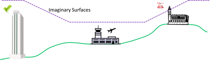 Figure 2: Safeguarding Surfaces
In the simplified diagram above the building on the right is an obstruction because it is higher than the imaginary surface above it. The building on the left is not an obstruction because it falls entirely below the relevant imaginary surface.
In this particular case some towers on high ground away from the runway approaches breached a safeguarding surface known as the Inner Horizontal Surface. Other assessed surfaces, which were not affected, include the Conical Surface, Approach Surfaces, Transitional Surfaces and Take Off Climb Surfaces.
Simulation of Pilots View
The view from the cockpit was simulated for a pilot flying a standard approach to each runway. A number of views were created at different ranges and approach angles. One of the views is reproduced below.
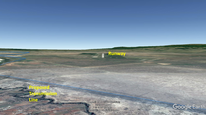 Figure 3: A view from the cockpit
Existing Transmission Lines
Fifty UK military aerodromes were identified with a range of transmission line distances between 1 and 9 nautical miles – the average distance being 3.5 nautical miles. The two aerodromes closest to transmission lines were heliports at Bovington and Fleetlands.
An in-depth study was undertaken into transmission lines at Joint Helicopter Command (JHC) Wattisham, in England, which has a long runway and is base to Apache and other helicopters. The chart below shows existing transmission lines in the vicinity of Wattisham.
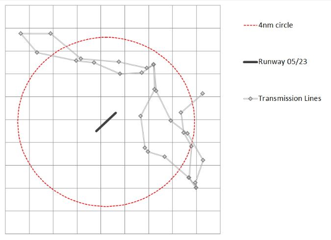 Figure 4: Existing transmission lines in the vicinity of Wattisham
The photograph below shows the transmission lines which are more than 60 metres high.
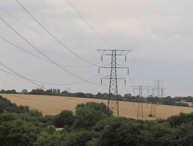 Figure 5: Transmission lines
Conclusions
The assessment showed that some transmission towers away from the approaches to the runway constituted obstacles because they breached the Inner Horizontal Surface.
The pilot’s eye view images showed that the transmission line would not affect aircraft flying standard approaches to the runway.
The UK military airbase research showed that there are many airbases with transmission lines within 4 nautical miles of the airbase.
Outcome
The Pager Power assessment is being used to support ongoing government discussions between the transmission line operator and the defence ministry.
[1] For reasons of confidentiality specific project information is not disclosed and in some cases has been changed in this article
[2] 1 nautical mile = 1.852 kilometres
post contents
About the Author: Mike
Latest News
Wind Turbine Consultation Open for the Eskdalemuir Seismic Array
What is the Eskdalemuir Seismic Array? The Eskdalemuir Seismic Array [...]
Iran War puts Renewables in the Spotlight
War and the Cost of Energy Wars have far-reaching impacts [...]

Why the Future of Solar Might Happen After Dark
Ever since the development and advancement of solar panels into [...]


