
Why do we need accurate modelling?
Wind turbine applications all over the world are subject to intense scrutiny from planners, local residents and even the media. Of principal concern are adverse impacts that could occur following construction of turbines. There are numerous types of impact, visual, ecological, technical, the list goes on.
Often this leads to a requirement for modelling of the potential issues in order to determine whether they will occur at all, how significant they might be and what is required in order to mitigate them. This is where the requirement for modelling comes in. All modelling is predictive and in order to make the results credible, it is vital to ensure that the approach followed is transparent, reliable and founded on reasonable/conservative assumptions.
How to ensure accurate modelling
The term ‘modelling’ is wide and applicable to a multitude of disciplines. Specific recommendations and best practice vary from topic to topic. However, it is generally important that any modelling is based on:
- Accurate source data
- A sophisticated approach that duly considers the most significant variables
- Current legislation or guidance
As an example, consider the potential for impact on terrestrial television signals in the area surrounding a proposed wind development. In order to accurately predict the potential impact, it is important to consider:
- Which transmitters serve the area
- The frequency of these transmissions
- The intervening terrain
- A suitable method for calculating potential degradation and/or reflection of the signal
- Any obligations put forward by relevant authorities such as a local council
The figure below [1] illustrates the relevant considerations required for a comprehensive assessment approach.
 Figure 1: Modelling approach (TV).
Terrain data
Many kinds of technical modelling require terrain data. This is applicable to visual impact, aviation concerns such as radar, TV signals, shadow flicker etc. Broadly speaking, terrain elevation is taken from a dataset based on values at a defined spacing interval. This can be based on the elevation of the terrain only, excluding obstructions above ground, or it can incorporate the effects of buildings and trees. These two types of dataset are known as ‘Digital Terrain Model’ (DTM) and ‘Digital Surface Model’ (DSM) respectively.
A common example of DTM data would be the contour heights shown on a map. A common example of a DSM would be the SRTM heights shown on things like Google Earth.
In order to get the best out of a good dataset, it is important to have a sophisticated algorithm that accurately predicts the height of the terrain at any point, not just at the specific points for which the heights are known.
This is a complicated topic, discussed further here, but three potential approaches and the difference in their results are illustrated in the figure [2] below.
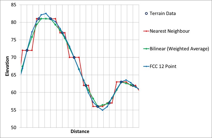 Figure 2: Interpolating terrain heights.
It can be seen that the choice of algorithm will affect the modelled value of the terrain. It is important to ensure that an appropriate choice is made based on which approach is the most accurate and which is the most conservative.
Here at Pager Power, we use the weighted average algorithm in analysis.
Pitfalls of inaccurate modelling
Use of inaccurate or over-simplified modelling is a dangerous practice. Significant issues that this can cause include:
- Failure to exploit good sites due to these being unnecessarily discounted.
- Safety risks that are missed by poor modelling.
- Financial consequences for the developer due to surprise mitigation costs arising post‑construction.
Summary
The renewable energy industry is dependent on detailed modelling at the planning stage. This is particularly important for wind developments due to their sheer size. In order to maximise the potential for such developments and to avoid unexpected costs it is vital to utilise accurate modelling methodologies.
References
[1] A GIS-based Decision Support Methodology for assessing wind turbine effects on television transmission: Establishing mitigation requirements and costs, Watson M., Georgopoulos J. Frolic K, 2010.
[2] Creating and Using Accurate Terrain Based Assessments, Watson M., 2012