Pager Power has launched a free terrain height tool – which allows you to obtain the height above sea level for any point in the UK or worldwide.
To find the tool, just visit our website (www.pagerpower.com) and select ‘free tools’ at the top right of the screen. No registration or personal information is required and the answer is received instantly [1].
All you have to do is enter the coordinates for the location you need – this can be entered as latitude and longitude, or for the UK you can use British National Grid (BNG) eastings and northings. Our system will return the height above mean sea level in metres for that location, with an image of the location on a map for reference.
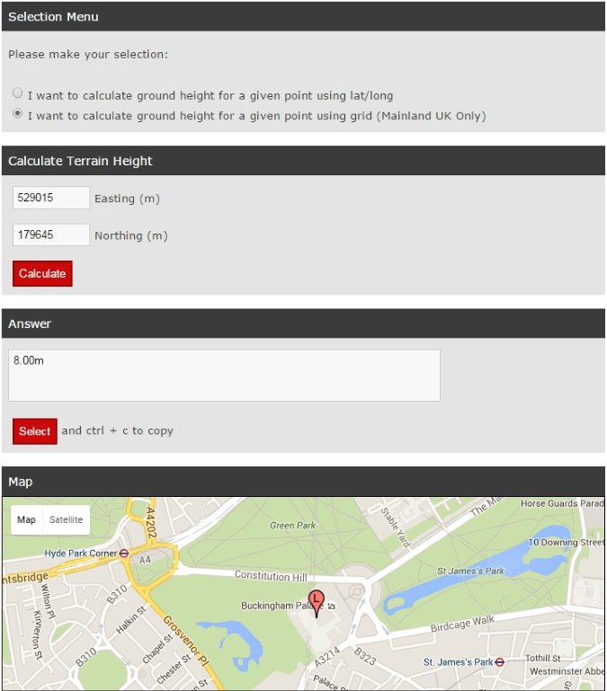 Figure 1: Terrain height tool.
Benefits
Accurate terrain data is crucial for developers of large infrastructure. Examples of developments that require accurate terrain data include:
- Building developments – The height above mean sea level for a building development is important. It can affect the building’s impact on radar, on TV services and on other limitations such as restricted areas.
- Wind farm developments – Terrain elevation affects a wind farm’s potential impact on aviation systems, communication systems and even shadow flicker effects.
- Solar developments – Terrain elevation affects the visibility of the panels to surrounding locations, which ties into visual impact as well as ‘glint and glare’ concerns. It is also relevant for shading considerations i.e. ensuring that the panels do not cast a shadow over one another.
Accuracy
A responsible assessment process should maximise the accuracy of its source data. In the case of terrain elevation, the most accurate approach is to undertake a site survey. For a desk-based assessment, the most comprehensive approach is to:
- Utilise the most accurate available Digital Terrain Model (DTM).
- Apply an accurate and conservative interpolation algorithm to the source data.
Typically, a DTM will provide data points at a fixed intervals. In the case of OSGB36 data – the industry standard in the UK – the interval is 50 metres in each direction. This means that data points that fall at an arbitrary location require interpolation to determine the most appropriate elevation value.
The figure below illustrates a number of approaches that can be taken when interpolating elevation data.
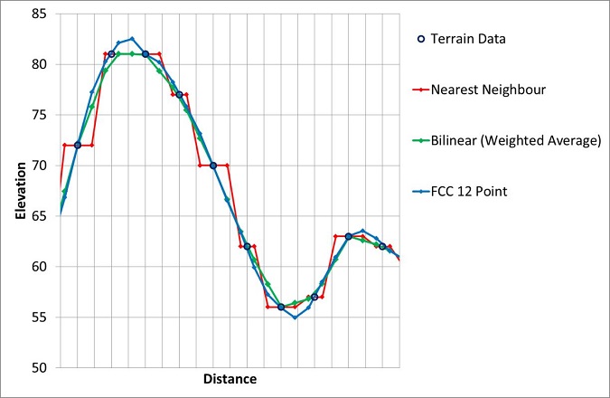 Figure 2: Data algorithms.
Pager Power utilises the bilinear approach for interpolating terrain data. It is our opinion that this approach strikes the optimal balance between accuracy and conservatism.
Source Data
Currently, we utilise the following:
- OSGB36 data for mainland UK locations, when coordinates are given in BNG.
- SRTM data for the rest of the world.
Summary
We have launched the free terrain data tool because we think it will be of value to many of our clients.
If you have any questions about the tool, or Pager Power’s services in general, please do get in touch.
Footnotes
[1] Note that the tool is new and we have not uploaded all data regions yet – please contact us if the location you need is not supported.