Civil Radar Constraints on Onshore Wind

Radar signals and wind turbines are, in a sense, natural enemies. Civil radar installations are generally located such that their coverage above the surrounding terrain is as unobstructed as possible. Wind turbines are generally located on the top of hills or ridges and made as tall as possible.
The most relevant categories of civil radar as they pertain to wind development are set out below. However, in general terms, the potential for interference stems from the fact that all radar systems emit an electromagnetic pulse, which interacts with a target of interest, and the returning signal is analysed to provide information about the target. Wind turbines, like any other physical structure, have the potential to interact with the radar signals to varying degrees, and this can affect the quality of the returning signal and, consequently, degrade the quality of the information.
This article focusses on civil radar constraints. An article focussing on military radar constraints can be found here.
Stakeholders
The stakeholders involved in radar safeguarding vary from one country to another. However, typical parties as it pertains to civil radar infrastrucure include the below, which is not an exhaustive list:
- Air Navigation Service Providers, who often safeguard civilian and/or military en-route traffic, and potentially some airport operations. Examples include NATS in the UK, LVNL in the Netherlands and ATNS in South Africa.
- Private airports, who often safeguard their own radar operations.
- Meteorological institutions, who often safeguard weather radar. Examples include the Meteorological Office in the UK and Meteo France in France (unsurprisingly).
- Civil aviation authorities, which typically have a regulatory capacity and are rarely involved directly within radar safeguarding.
Primary vs Secondary Radar
Aviation radar are often categorised as “primary” or “secondary” (named in order of their invention, not their importance).
Primary radar works a bit like a lighthouse, but with an electromagnetic signal that has a much higher frequency than visible light. A primary radar rotates, all the while emitting a radio signal in all directions. This signal then bounces off objects that it encounters, e.g. an aircraft, and the echo is received by the radar on the ground. The direction from which the echo is received, combined with the time taken for it to arrive, gives a bearing and a range to the target. Incidentally, the word ‘radar’ comes from Radio Detection And Range.
Secondary radar is slightly more sophisticated, it also rotates and emits a radio signal in all directions, but this one is received by transponders on board aircraft, which then send a reply signal back to the radar.
An advantage of secondary radar is that replies only come from transponders, not from unintended targets. Another is that the reply signal can include lots of helpful information, perhaps most notably altitude and flight number, that is not discernible from primary radar systems. An advantage of primary radar is that it can detect targets whether they like it or not, i.e. aircraft that do not have transponders (or do not have them switched on), can still be detected.
Primary radar systems are sometimes denoted as ‘non-cooperative’ while secondary ones are denoted ‘cooperative’.
Primary radar are generally more susceptible to interference from wind turbines, however impacts on secondary radar are also possible and constraints arise due to both types as a result.
Types of Mitigation
Radar mitigation is a very broad and dense subject in its own right, this is not covered in depth here. However, an overview of the extent to which mitigation is typically available will be given for context purposes. With this in mind, it is important that we distinguish between two categories of mitigation:
- Technical mitigation – by which something is there is some change made to the hardware and/or software associated with the radar system and/or the turbines themselves. This could include the incorporation of in-fill coverage from an alternative radar, or the application of a stealth coating to a turbine blade, for example.
- Operational mitigation, whereby the impact is tolerated as being acceptable. It is often subject to marking the turbines’ presence on associated charts and other published information or changing specific flight procedures and airspace.
Civil Radar: Air Traffic Control
Licenced civil airports that process passengers often have radar installations for managing air traffic approaching and departing the airport. Other types of civil aerodromes can also have radar, but it is less common. Such radar can be primary and/or secondary.
The impact of concern for primary radar is the potential for a wind turbine to reflect a radar signal back towards the radar itself and be mistaken for an aircraft. The risk of this is exacerbated by the fact that most primary radar systems are two-dimensional and wind turbine blades move very fast.
Technical mitigation solutions for primary radar exist, and while many of these are dependent on the type of radar (among other things), in principle these are applicable to military air traffic control radar. As ever, this requires a cooperative effort from the developer and the stakeholder, and the cost of the solution vs the value of the development comes into play. In very general terms, the issue is usually solvable if there is enough budget and time to pursue a solution. Operational mitigation for military air traffic control radar is also possible subject to the development being located outside areas of key significance to the air base.
The impact of concern for secondary radar also stems from the potential for the turbines to reflect radar signals. However, turbines do not have transponders and cannot be mistaken for aircraft by a secondary radar system. They can, however, affect the accuracy of the data relayed between the radar and an actual aircraft under certain conditions.
Technical mitigation options for secondary radar are more limited than those for primary radar systems, however the level of impact on secondary radar from turbines is also less than the impact on primary radar, all things being equal.
Impacts on civil air traffic control radar can stop projects going ahead, but this is an area where advances have been made in recent years.
Such radar systems are typically safeguarded by the airport itself or a civil Air Navigation Service Provider.
Civil Radar: En-Route
Many countries operate a network of long-range civilian radar for the purpose of monitoring en-route traffic, often within controlled airspace. In the UK, for example, the main Air Navigation Service Provider is NATS, more information about them is available here.
En-route radar can be primary and/or secondary. The associated impacts of wind turbines are the same as those for military or civil air traffic control radar, as described above.
Technical mitigation options for en-route radar exist, and while each situation must be considered on a case-by-case basis, it is generally true that impacts on en-route radar can be mitigated via a commercial agreement with the operator. This is mostly because a sophisticated en-route radar network will have coverage over swathes of the country, such that solutions for wind turbine impacts must be coordinated accordingly. It is noteworthy that the increases in turbine size for modern development do make things a little trickier in this regard. More information on this toic can be found in our Aviation and Onshore Wind guide, available here.
Such radar systems are typically safeguarded by a civil Air Navigation Service Provider.
Civilian Radar: Meteorological
Meteorological institutions typically operate a network of weather radar to assist in weather prediction and monitoring.
The principle behind such radar systems is similar to primary radar systems described above. The radar frequency is different than aviation radar, and so is the mode of operation, with scans typically going through 360 degrees at incrementally increasing vertical angles. The target of interest for a weather radar is precipitation in the air, not aircraft. Nevertheless, reflections of the radar signal by wind turbine blades can corrupt the data acquired by such systems, or potentially be mistaken for an extreme weather event.
Safeguarding ranges for weather radar typically do not extend beyond 30 kilometres (although in some cases they do), and as such they do not affect as much land area as some other types of radar.
Mitigation options for weather radar exist, but are less extensive than those that have been devised for aviation radar. Developments that are in close range of a meteorological radar can be significantly constrained.
Such radar systems are typically safeguarded by a meteorological office or institution.
Figure 1 below summarises the main civilian radar constraints for onshore wind development.
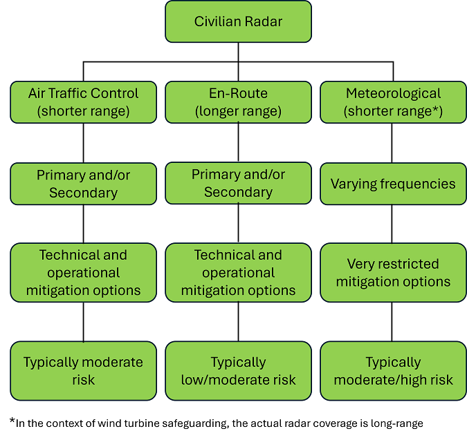
Figure 1 – Summary of main civilian constraints (onshore wind)
Other Radar Types
There are a whole host of other radar types that exist and have not been covered here. These are generally radar types that are rarely, if ever, impacted by onshore developments. These include:
- Vessel Transport Service radar (located at ports, sometimes affected by onshore wind).
- Marine radar (located aboard ships, rarely affected by onshore wind).
- Surface movement radar (located at airports, rarely affected by onshore wind).
- Airborne radar (in certain military aircraft, not known to be affected by onshore wind).
- Ground Penetrating Radar (geological applications, not known to be affected by wind).
- And more!
Whilst these radar types do not have a historical track-record of being significant constraints to wind, a detailed understanding of the radar environment within which a project is proposed remains an essential aspect of onshore wind development.
Pager Power
Pager Power has been modelling radar impacts associated with onshore wind for over 20 years. If you have queries about your onshore wind project, please do not hesitate to get in touch.
Thumbnail image accreditation: Tim Foster (May 2017) on Unsplash.com. Last accessed on 8th October 2024. Available at: https://unsplash.com/photos/three-windmills-on-top-of-the-hill-CRsDbS_pHkE
post contents
About the Author: Kai Frolic
Latest News

US Continues to Build Out Solar Capacity
Earlier this month, the Solar Energy Industries Association (SEIA) released [...]

China’s Airborne Wind Turbines
In early 2026, China successfully developed an airborne wind turbine [...]
Shadow Flicker Assessments for Wind Turbines: A 2026 Update
Shadow flicker is the effect of rotating turbine blades, causing [...]


