The role of NATS and where they operate in the UK

Overview
If you are developing a wind farm or building development in the vicinity of an airport, radar installation or navigation aid, then it will be beneficial to know who safeguards the infrastructure. NATS is one of the UK’s largest aviation stakeholders, and they have the responsibility of maintaining and safeguarding a number of radar installations, airports and navigation sites across the country. Identifying these relevant sites, understanding any potential impact and consulting with NATS early may therefore be beneficial for managing costs and the planning timeline of your project.
Location of NATS Radar
NATS operate their own en-route radar whilst also providing safeguarding services for a number of external radar sites across the UK. Figure 1[1] below shows the general locations of radar sites safeguarded by NATS across the UK.
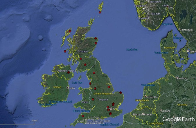
Figure 1: General location of NATS radar installations
The safeguarded range for each site may vary depending on the radar type and the development being proposed in its vicinity. For example, wind turbines will have more stringent safeguarding criteria compared to a building development. More information on the interaction between tall buildings and NATS radar can be found here. Further information on wind turbine radar interference can be found here.
NATS Air Traffic Control Services
NATS provide air traffic navigation services for a number of UK airports[2]. The location and name of these airports is shown in Figure 2 below. A radar is not present at all of these airports, instead NATS can utilise the coverage from a network of radar located at sites all over the UK (as shown in Figure 1).
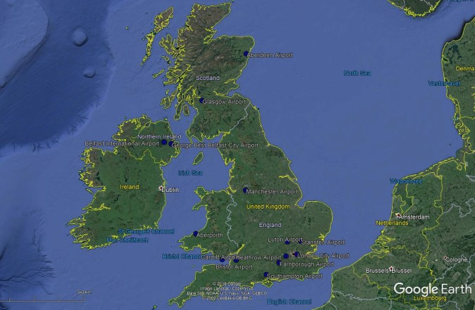
Figure 2: Locations where NATS provide air traffic navigation services
Air Traffic Controllers have many roles, but those that may be affected by the presence of wind or building development include managing aircraft in the en-route phase of flight or those aircraft approaching, departing or circling airports. Where wind and building developments are located close to a navigation aid or in the vicinity of manoeuvring aircraft, ATC services may be affected. The impact upon ATC services may therefore be technical (i.e. interference to radar signals) or physical (i.e. the development as an obstruction) where the vertical clearance between an aircraft and a development cannot be maintained by following existing procedures. Where NATS offer air traffic navigation services, NATS will be a key consultee if the provision of their services may be affected. If an impact is expected, an objection from NATS on behalf of the relevant airport is possible. In some instances, the airport and NATS will both offer safeguarding services for the airport, for example Heathrow Airport. Figure 3[3] below shows the co-mounted Primary Surveillance Radar (PSR) and Secondary Surveillance Radar (SSR) safeguarded by NATS. Heathrow Airport also safeguard the airport themselves, for example regarding their Obstacle Limitation Surfaces (OLS).
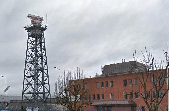
Figure 3: Heathrow Airport’s co-mounted PSR and SSR
What is the process?
The first step is to identify the relevant aviation infrastructure in the area around your proposed development. This can be undertaken by undertaking Pager Power’s free Aviation and Radar Report which will identify, not only NATS infrastructure, but all of the most significant potential aviation risks in the UK. The next step is to understand whether an impact would be expected and to undertake consultation with NATS or the relevant stakeholder, where necessary.
Conclusions
Pager Power knows of all UK NATS sites which require safeguarding. If you are unsure whether your proposed development may affect NATS safeguarded infrastructure, please get in touch.
Alternatively, you can complete our free Aviation and Radar Report which will identify any NATS risk your development may face.
References
[1] © 2018 Google. Data SIO, NOAA, U.S. Navy, NGA, GEBCO. © 2009 Geo Basis-DE/BKG. Image Landsat/Copernicus
[2] https://www.nats.aero/about-us/where-we-operate/
[3] © 2019 Google.
post contents
About the Author: Danny Scrivener
Latest News
Dutch Temporary Framework for Solar near Airports
In March 2025, glare from a nearby solar farm temporarily [...]

Onward 2030 Work Package 3: The Future of Wind Mitigation
Onward 2030 Work Package 3 (WP3) has been produced with [...]

What is Electronic Conspicuity, and How Could it Unlock Onshore Wind?
Electronic Conspicuity (or EC) is a term used to describe [...]


