Terrain Data – Everything You Need to Know
 – news article – holding image")
Every location on land has an altitude above (or, in some rare cases, below) sea level. Most people have better things to do with their day than to ponder what that altitude is, where such values are stored in datasets and how those datasets may be used. However, if such questions do keep you up at night, this is the article for you.
Terminology
Some definitions are set out below:
- Mean sea level – This is the average vertical level of the sea over a long period of time.
- Vertical datum – This is a reference point for vertical positions in space. Whilst this can be defined in various ways, the terms ‘above datum’ and ‘above mean sea level’ are often used interchangeably.
- Altitude – This is a value (often in metres or feet) that defines the vertical position of a point in space relative to mean sea level.
- Elevation – This is essentially the same as altitude. It is common for the position of terrain to be described as having an elevation of e.g. 50 metres above mean sea level. For a structure such as a lighthouse, it would be more common to refer to an altitude of e.g. 70 metres above mean sea level.
- Height – This is a value (often in metres or feet) that defines the vertical position of a point in space relative to ground level.
The above is illustrated in Figure 1 below.
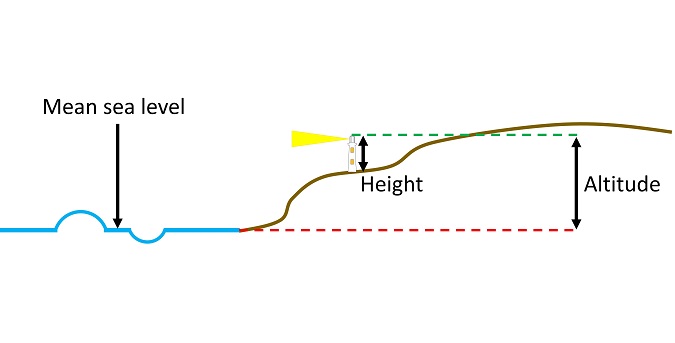
Figure 1: Simplified illustration of height and altitude.
Some acronyms that you may come across are listed below. The first two are discussed in more detail in the following sections:
- DTM – Digital Terrain Model. This type of dataset contains elevation data for terrain, often at a fixed resolution.
- DSM – Digital Surface Model. This type of data set contains elevation data for the surface, whether it is terrain or a structure, often at a fixed resolution.
- DEM – Digital Elevation Model. This is any dataset of vertical data for a set of coordinate values. This can be a DTM, a DSM or a hybrid of the two.
- AMSL – Above Mean Sea Level. This is sometimes added after a specified value for further clarity.
- AGL – Above Ground Level. This is sometimes added after a specified value for further clarity.
Digital Terrain Model
A Digital Terrain Model (DTM) stores vertical elevation data for terrain within a defined area, often on an evenly spaced grid at a defined resolution.
The vertical data describes the elevation above mean sea level of the ground, with no consideration of structures above the surface such as buildings, trees or vegetation.
A DTM is sometimes referred to as a ‘bare earth model’ or similar because it comprises data for the ground only.
Digital Surface Model
A Digital Surface Model (DSM) is conceptually very similar to a DTM, but it describes the surface including any obstructions. This means the elevation of buildings etc is captured within the data.
Figure 2 below illustrates the difference between a DTM and a DSM.
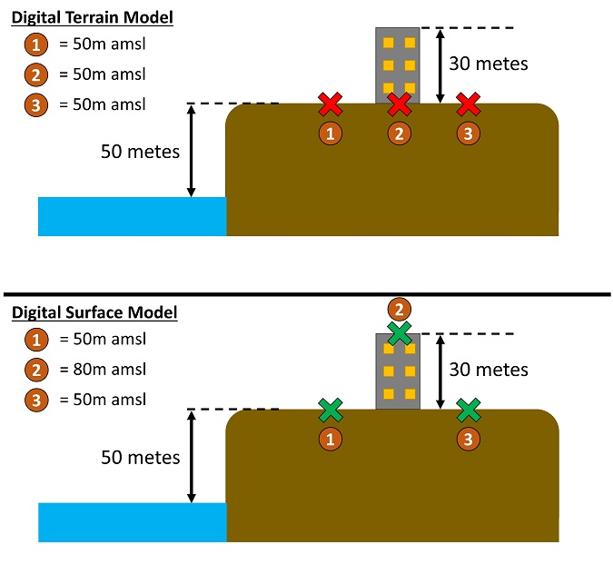
Figure 2: Difference between DTM and DSM.
Common Data Sources
DEM data is often available from:
- National organisations that provide survey data within their country, for example Ordnance Survey of Great Britain for the UK.
- Global datasets that cover large parts of the world, for example Shuttle Radar Topography Mission (SRTM Data).
- Bespoke sources of high-resolution data e.g. Laser Imaging Detection and Ranging (LIDAR) surveys for a small area of interest.
Confusion with Coordinate Systems
A DEM is defined by:
- Whether it is a DTM, DSM or a hybrid.
- The vertical datum to which it refers.
Coordinate systems are not discussed in this article for fear of making it too exciting, but the most common types of coordinate systems are:
- National Grids – which approximate the country as if it is on a flat surface rather than a curved surface.
- Angular systems (for example latitude and longitude) – which define locations horizontally based on a horizontal and vertical angle with reference to a defined origin.
The choice of coordinate system is in principle independent of the coordinate system that is used. In practice, common coordinate systems are often used with associated DEMs.
Applications of Digital Elevation Models
DEMs are very important for a variety of applications, notably for the development of infrastructure. Reasons for this include:
- Ensuring heights and altitudes comply with safety requirements. An example of this would be the development of a tall building at an airport, where altitudes are strictly controlled to manage collision risk. For such applications, it is common practice to use a DTM or bespoke survey for such applications. This is because the ground at a building development location is often unoccupied or gets levelled before the new construction starts.
- Evaluating the visual impact of a proposed development on the surrounding residential areas. For such applications, use of a DSM may be more appropriate because views can be significantly blocked by existing buildings, existing vegetation or proposed planting. Another common strategy is to undertake technical modelling based on a DTM and incorporate overground structures thereafter.
- Evaluating glint and glare effects for solar photovoltaic developments. In this case, the potential for geometric reflections is dependent on the three-dimensional position of the panels relative to observer locations.
There are many other examples of applications that utilise DEMs.
Interpolating Digital Elevation Models
It is common for DEMs to have a fixed spacing horizontally and vertically, with data values attributed to each point. Since this spacing is often around 50 meters, specific points of interest often lie between locations with known values. It is therefore necessary to interpolate the value at the location of interest. This is illustrated in Figure 3 below.
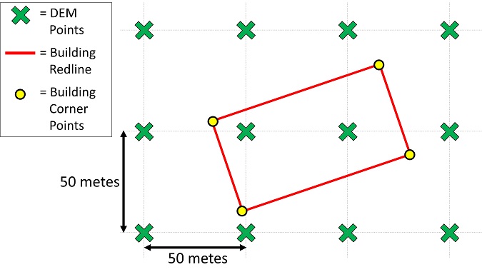
Figure 3: Interpolating DEM data
The building corner points do not fall on the grid boundaries that have exact heights. A methodology is therefore needed to ascribe values to each corner point. Options include:
- Nearest Neighbour approach – whereby the vertical value of a given point is taken to be exactly the vertical value of the nearest DEM point. This method is very simple to implement but is also not very sophisticated or accurate. It may be appropriate for some applications where accuracy does not need to be maximised, such as high-level analysis or as a crosscheck of a primary data source.
- Weighted Average approach – whereby the vertical value of a given point is based on a weighted average of a number of surrounding DEM points. This is a more accurate but slightly more complex method than the Nearest Neighbour approach.
- Face-Centred Cubic approach – which is a more sophisticated averaging process that seeks to capture the slopes of the surrounding area to estimate peaks and troughs accurately. This type of approach can be the most accurate, but may not be the most conservative.
The appropriate methodology should be determined based on the application.
About Pager Power
Pager Power is a technical consultancy that analyses technical constraints on large-scale development. Much of our technical work is underpinned by terrain-based analysis that incorporates Digital Elevation Models and advanced interpolation algorithms. Examples include:
- Radar impact analysis for buildings and wind farms.
- Glint and glare analysis for photovoltaic developments or building façades.
- Telecommunications analysis including propagation of electromagnetic signals through free space and/or terrain.
If you have a project that we can help you with, please do get in touch.
Thumbnail Featured Image: Silver and Black Solar Panels on Snow Covered Ground (August 2016) from Pexels.com. Last accessed 15th Nov 2021. Available at: https://www.pexels.com/photo/silver-and-black-solar-panels-on-snow-covered-ground-159160/
post contents
About the Author: Kai Frolic
Latest News

Anti-Glare Solutions for Solar Panels
Depending on the surface conditions reflections of light can be [...]
How Can Glare Risks be Reduced for my Solar Project?
Glare is an important environmental impact to consider during the [...]
Wind Turbine Consultation Open for the Eskdalemuir Seismic Array
What is the Eskdalemuir Seismic Array? The Eskdalemuir Seismic Array [...]


