Pager Power Launches Aviation Feasibility Maps

Last Updated: September 28, 2026
Share:
Early this month, Pager Power appeared at the Onshore Wind Conference 2026, and delivered a short presentation on our new Aviation Feasibility Maps as a part of the Supplier Showcase.
This article will include further details on what exactly our Aviation Feasibility Maps include, and how they can assist you with early-stage feasibility analysis for potential wind farm sites.
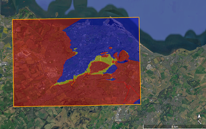
Figure 1 OLS Layer for Aviation Feasibility Map
What do the Maps Cover?
The Aviation Feasibility Maps cover three primary risk areas relating to aviation: radar, Obstacle Limitation Surfaces (OLS), and High-Level Instrument Flight Procedures (IFPs).
Within each of these areas, consideration is given to the potential risk presented to your development by infringement of existing aviation infrastructure and restrictions. These risks are then sorted into four colour-coded categories:
- Red – severe risk to the project, likely not to be feasible
- Amber – moderate risk to the project, likely to require significant mitigation
- Green – low risk to the project, likely to require minor mitigation and/or notification
- Blue – no risks identified
These colours can then be mapped to provide a quick view of the predicted risk levels at different locations within a wider region, assisting in site origination and feasibility analysis. These maps can be provided as Shapefiles or KMLs, to enable integration with your software.
What Aviation Constraints are Considered?
Within the category of radar risk, consideration is given to military radar (including air defence and aerodrome radar), civil radar (including en-route and ATC radar) and meteorological radar.
For obstacle risk, detailed OLS modelling is conducted for any licenced military and civil aerodromes and unlicenced general aviation aerodromes are included at a high-level.
For instrument flight procedures, consideration is given to area minimum altitudes, surveillance minimum altitudes and circling minima. This does not consider individual procedures and flight routes, but it gives an indication of the IFP risk from nearby civil and military aerodromes.
Why is this Useful?
Having an Aviation Feasibility Map during the site selection process can allow aviation constraints to be identified at an early stage of site origination and development, drive early engagement with relevant stakeholders, avoid late-stage aviation objections derailing the project, and prevent unwanted mitigation costs down the line.
Whilst the map may not completely remove aviation concerns, it will provide meaningful insight into site constraints and act as a guide for the consultation process. By the time a detailed Aviation Impact Assessment is conducted for your development, for planning submission, there should be a degree of assurance that the relevant aviation constraints are already known and that any risks have been accounted for in advance.
Considering a Renewable Energy Development?
Pager Power is a dedicated consultancy firm with many years of experience in assessments of aviation safeguarding, telecommunications, glint and glare and more. If you’re planning a renewable energy development and would like advice at any stage please get in touch, from initial advice over the phone, all the way to technical assessments for planning application.
Image accreditation: Rita Candeias (May 2022) from Unsplash.com. Last accessed on 28 September 2026. Available at: https://unsplash.com/photos/a-city-skyline-at-night-UW-x4vc9Z2M
post contents
About the Author: James Plumb