Background
Pager Power provides a national dataset that helps wind farm developers focus on areas where they are less likely to encounter aviation and radar objections. This news article explains what data is available and how to use it. It also explains the limitations of the data.
How Should Developers Use This Data?
Some developers undertake top-down searches of the British Isles. They use GIS systems with layers containing information about wind-speeds, electricity grid availability, nearby properties, topography and planning designations. The GIS system then highlights areas of search for new wind farm sites. Many of these sites will not progress due to radar and aviation issues.
Some developers use crude methods (for example, simple distance criteria) to model aviation and radar constraints resulting in the selection process ruling out good sites.
By integrating Pager Power aviation and radar risk data into their GIS systems, wind developers can build an improved pipeline of new wind farm sites.
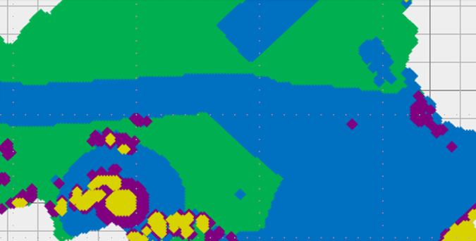
Figure 1: Graphical representation of risk data sample – Scotland.
What Form Does The Data Take?
The data consists of nearly one million data points spaced at 500-metre intervals across mainland Britain. Each data point has a risk score reflecting the likelihood of a wind farm having aviation and radar objections that may be unresolvable. The name of the airport or radar of most concern is provided with each data point.
The data can be imported to GIS systems and combined with other data layers to help developers home in on good wind farm areas.
Which Airports And Radar Are Included?
Almost all civil and military radar and aerodromes are included ranging from air defence radar to private airfields. Please feel free to contact us for a comprehensive list of the types of installations included.
What Are The Limitations Of The Dataset?
The dataset needs to be prepared for a particular turbine height. The dataset can also be adjusted to reflect the developer’s appetite for aviation risk. For example some developers prefer sites with complex issues that could be resolved whereas others are keen to avoid all issues.
The dataset is designed to help the site selection process. It is not designed for the evaluation of sites once they have been found. This difference appears subtle – but is important in practice.
What Are The Next Steps?
The next steps are likely to involve a discussion to better understand your requirements. This might be followed with a data sample being provided for you to evaluate within your GIS system.
About Pager Power
Pager Power has been managing aviation concerns for developers for over 20 years. We provide services internationally, including technical assessment, stakeholder engagement, mitigation studies and more.
If you have a project that could be constrained by these issues, or if you would just like some more information, please don’t hesitate to get in touch.

