Why are Glint and Glare Effects Towards Local Roads Considered a Low Impact?

Introduction
The first stage of assessing the potential impact of glint and glare towards surrounding road users involves undertaking an initial review of the available imagery to determine the specific roads to be taken forward for geometric modelling. Local roads are not typically taken forward for geometric modelling because the significance of any impacts towards these roads are considered to be low, despite the predicted visibility of the proposed development.
In this article, we explain how local roads are identified by Pager Power, and why glint and glare effects towards local roads are considered a low impact.
Road Classifications
Road types can generally be categorised as:
- Major National – Typically a road with a minimum of two carriageways with a maximum speed limit of up to 70mph. These roads typically have fast moving vehicles with busy traffic.
- National – Typically a road with a one or more carriageways with a maximum speed limit 60mph or 70mph. These roads typically have fast moving vehicles with moderate to busy traffic density.
- Regional – Typically a single carriageway with a maximum speed limit of up to 60mph. The speed of vehicles will vary with a typical traffic density of low to moderate.
- Local – Typically roads and lanes with the lowest traffic densities. Speed limits vary.
The roads classifications are based on typical UK roads; however, they are applicable internationally. Whilst there may be some variation between road classifications in different countries, the general premise of typical traffic levels remains the same i.e., major national roads have the highest traffic densities and local roads have the lowest traffic densities.
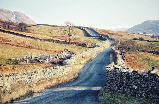
Figure 1: Local road in the countryside. [1]
Identifying a Local Road
Most major national and national roads are easy to distinguish because they range from large motorways (e.g., the M25) to smaller A roads (e.g., the A120). Differentiating between regional and local roads is often less apparent at first glance and therefore further consideration is required to classify specific roads.
Regional roads (typically B roads) are more than purely local but less than national strategic importance in a country’s highway network. Local roads (typically C roads and unclassified roads) mostly have no defined destination and often have no road markings.
To determine whether a road is a local road, Pager Power undertakes a review of available online imagery, Google maps, and road maps, paired with professional judgment. Using the definitions above, the following characteristics are used in combination to signify a local road:
- The road is narrow in width – wider roads are required for higher traffic densities.
- There is no clearly marked centre line defining the left- and right-hand side of the road. This is a good indicator that a road is of low traffic density because roads with higher traffic densities are typically maintained to higher standards (e.g., road marking, signs, labelling etc.) by the appropriate highways’ authority.
- Speed limit on the road – major national or national roads, typically with two carriageways, have higher speed limits.
- The number of cars found on local roads on the available street view imagery – this is indicative only and does not necessarily reflect expected traffic levels. Local roads with low traffic densities are more likely to have minimal to no vehicles found.
- Mapping software typically marks those roads of higher road categorisations.
Why Low Impact
The potential impact upon road users along local roads is not considered to be significant under any scenario because local roads are of less significance to road networks and of lesser sensitivity to reflections. This is primarily due to the road type typically having the lowest traffic densities, which means the potential impact of a distraction or degradation to safety and/or operation due to a solar reflection is low.
Traffic densities have a significant effect on the sensitivity of a road user because this has implications on their workload. A road user will require much greater level of concentration to safely travel along busy roads at high speeds, compared to the level of concentration required to safely travel along empty roads at slower speeds.
Local roads may, in some instances, prove to be vital to the surrounding road network. Therefore, consultation with the local highway authority is recommended to ascertain the significance of a surrounding road where it is unknown. If known to be vital to the surrounding road network, the local road should be taken forward for geometric modelling alongside the major national, national, and regional roads.
About Pager Power
Having completed over 1,100 glint and glare assessments in the UK and internationally, Pager Power has extensive experience assessing the impact of glint and glare upon roads users surrounding solar and building developments.
If you are a developer who is concerned about potential impacts of glint and glare towards surrounding road users from one of your projects, feel free to contact me on michael@pagerpower.com.
References
[1] George Hiles (June 2018) from Unsplash.com. Last accessed on 3rd August 2023. Available at: https://unsplash.com/photos/sIStm4lm1Copost contents
About the Author: Michael Sutton
Latest News

Anti-Glare Solutions for Solar Panels
Depending on the surface conditions reflections of light can be [...]

How Can Glare Risks be Reduced for my Solar Project?
Glare is an important environmental impact to consider during the [...]
Wind Turbine Consultation Open for the Eskdalemuir Seismic Array
What is the Eskdalemuir Seismic Array? The Eskdalemuir Seismic Array [...]


