CNS Equipment Deep Dive, Part 3: Navigation

As promised in our earlier instalments, today we embark on the second component of the Communications, Navigation, and Surveillance (CNS) trio – Navigation. This article explores the navigation systems that guide aircraft when flying both en-route and in proximity to an airport, and how new development might interfere with their capabilities.
What is Aviation Navigation?
Navigation systems are those that enable pilots and air traffic controllers to determine aircraft positions, maintain course, and facilitate safe departures, arrivals, and en-route operations. Navigation facilities are often used for flight under Instrument Flight Rules (IFR), where weather conditions are such that visual references cannot be used to know the aircraft’s position in space or the position in space that they need to fly.
Technology used for navigation has developed in complexity over the years, moving from radio ground-based systems in the Very High Frequency (VHF) range, to modern satellite-based systems. Despite the modern satellite-based systems, the older radio ground-based systems are still used in tandem to ensure safe flight today.
Types of Navigation System
The main navigation systems used in the UK are presented in Table 1 below.
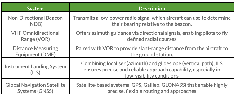
Table 1: Types of navigation systems.
The table shows that different navigation systems are often used in tandem to provide the greatest context to a pilot and to maximise accuracy. For example, the glide path and localiser facilities used for an ILS are two separate facilities located in different places on the aerodrome. Yet, the information is presented to the pilot on a single instrument in the cockpit.
A representation of an ILS cockpit instrument is presented in Figure 2 below. The horizontal green line gives the pilot the glideslope information and the vertical line gives the localiser information. By keeping the crosshair in the middle of the instrument, the pilot will know that it is on the correct approach into land at the aerodrome despite limited to zero visibility due to weather conditions.
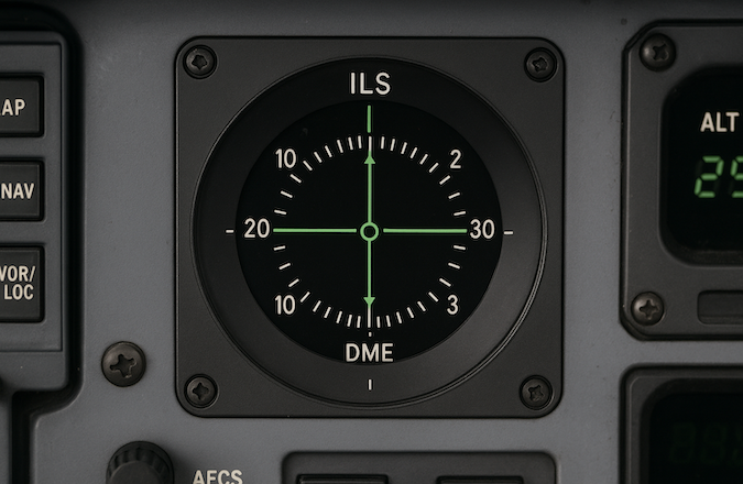
Figure 2: ILS instrument representation.
Potential Impacts from Developments
Like with communications systems, large structures such as buildings or wind turbines may:
- Block line-of-sight between aircraft and ground transmitters;
- Cause radio reflections or shadowing, particularly in hilly terrain;
- Introduce electromagnetic interference if emitting within sensitive frequency bands.
Navigation systems are unique in that many are directional, meaning that they are proving navigation to aircraft in a specific bit of airspace. Again, using an ILS as an example, aircraft will be approaching from the extended runway centreline and therefore the facilities will utilise directional beams centred on the optimal approach height and position.
This makes the navigation facilities more sensitive than communications and surveillance facilities if new development is in between the facility and the specific airspace where aircraft will be. Navigation facilities are also typically located on the aerodrome, making them susceptible to interference from new development in and around the aerodrome.
Summary
Navigation systems provide aircraft guidance and precise positioning and are especially important when weather conditions do not allow flying using visual references. It is important to consider the impact of new development in the vicinity of an aerodrome which has navigation facilities, especially due to the importance of the facilities that provide positioning information to landing and departing aircraft.
Stay tuned for Part 4 in the series, where we’ll explore the third component: Surveillance.
Pager Power
Pager Power has experience constructing Building Restricted Areas around CNS equipment at airports around the world to determine whether they could be impacted by new obstacles.
If you are working on a project where concerns have been raised in relation to CNS equipment, please reach out on +44 01787 728167 or email michael@pagerpower.com.
Image accreditation: Oskar Kadaksoo (October 2019) from Unsplash.com. Last accessed on 13th August 2025. Available at: https://unsplash.com/photos/a-close-up-of-the-cockpit-of-a-plane-MKh27bPCPGc
https://www.pagerpower.com/wp-content/uploads/2025/08/CNS-Navigation-Thumbnail.jpeg
post contents
About the Author: Michael Sutton
Latest News

US Continues to Build Out Solar Capacity
Earlier this month, the Solar Energy Industries Association (SEIA) released [...]

China’s Airborne Wind Turbines
In early 2026, China successfully developed an airborne wind turbine [...]

Shadow Flicker Assessments for Wind Turbines: A 2026 Update
Shadow flicker is the effect of rotating turbine blades, causing [...]


