Introduction
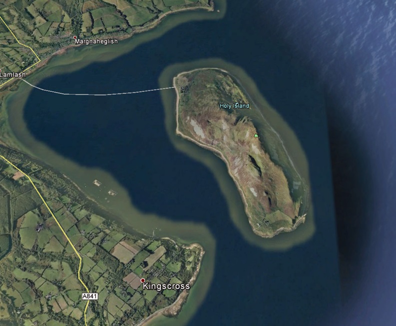
Pager Power was engaged to assess the impact of the Holy Isle Wind Development, a six-turbine[1] scheme located on Holy Isle in Scotland. Specifically, the engagement was to assess the potential impact of the three southern wind turbines upon the Primary Surveillance Radar (PSR) at Glasgow Prestwick Airport (GPA), following an initial objection. Figure 1[2] shows an aerial image of Holy Isle.
The following case study presents an overview of the project, the problems encountered and the analysis, which lead to planning permission of the Holy Isle Wind development.
Background
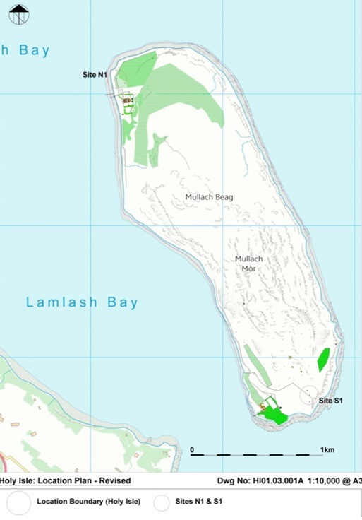
The initial proposal for the Holy Isle Wind Development consisted of six wind turbines, three to the north west and three to the south of the island. The height of each wind turbine was 20.2 metres to tip. The original location of the proposed wind turbines can be seen in Figure 2.
GPA assessed the initial proposal and responded with the following[3]:
‘The turbines to the north of the Isle are terrain shielded and do not present a safeguarding issue for GPA. The turbines on the south of Holy Isle will be in full line of sight to the Primary Surveillance Radar (PSR). This means that they would display as clutter on the radar displays.’
‘The development is located outside GPA’s Controlled Airspace therefore Air Traffic Control will have to avoid vectoring aircraft within 5nm of the clutter. This will have an impact on all our traffic routing to GPA from the west coming from the GPS waypoint Machrihanish to a final approach for Runway 12… We would have to route our traffic further track miles either north or south to avoid the clutter thus increasing fuel usage.’
‘The clutter is also within 5nm of the heliport at Brodick on Arran. This is where the emergency services such as the Police, Ambulance and Search and Rescue helicopters operate from. Having clutter in this location limits the ability to provide a de-confliction service to these flights if required by the pilot or due to weather.’
‘As a general guide the CAA document CAP 764 Policy and Guidelines on Wind Turbines, Chapter 2 details the known effects of wind turbines on PSR including desensitisation which could cause the aircraft return to drop out, masking of true targets and false targets.’
‘Therefore for the reasons stated above GPA objects to the application. However, GPA would encourage the developer to get in touch to discuss these issues further.’
The objection to three southern proposed wind turbines lead to the engagement of Pager Power to identify possible ways forward for the wind development.
The Challenge
There were a number of prominent challenges associated with this project, these included:
- Finding locations where a turbine would not be visible or detectable to the PSR at GPA
- Gaining accurate terrain data for incorporating into the Line of Sight (LOS) and Radar Detectability Analysis
- Providing sufficient evidence to GPA so that they would remove their objection
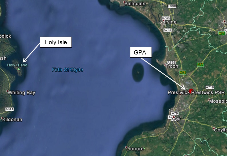
The relative location of Holy Isle to GPA is shown in Figure 3[4].
The Process
The initial study investigated the radar detectability of the three proposed southern wind turbines. This showed that the three wind turbines, measuring 20.2 metres to tip, would be ‘likely’ to be detectable to the PSR at GPA.
For the second study, a greater number of southern wind turbines in different locations were assessed, each with a smaller tip height of 12.2 metres. The analysis again revealed that all of the wind turbines would be visible to the PSR by varying margins. This time the Radar Detectability Analysis revealed that the wind turbines would be ‘unlikely’ and ‘highly unlikely’ to be detectable to the PSR.
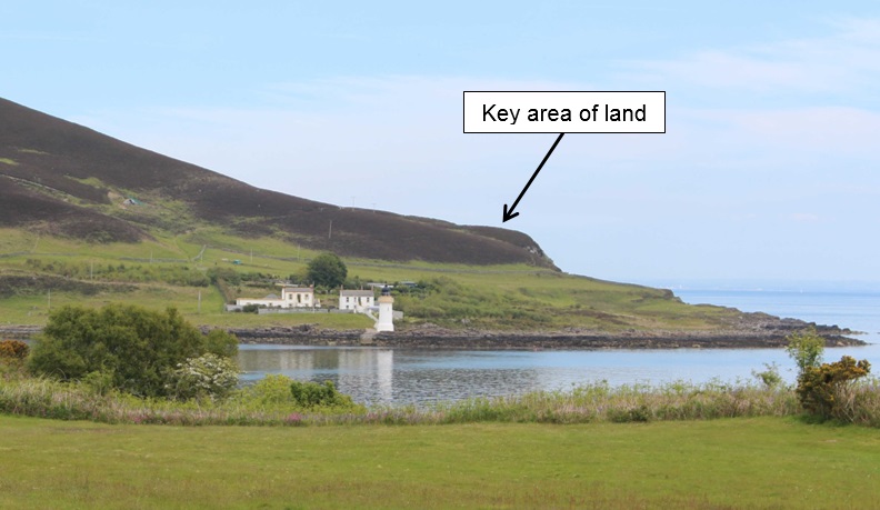
Following this, it was identified that the typical terrain databases may not accurately account for a key area of raised terrain to the south west of the island that may provide screening from the PSR. This area is shown in Figure 4 below. Therefore, a terrain survey was completed to gain accurate height measurements. Accurate heights were vital in establishing whether the wind turbines may indeed be visible to the PSR.
The Solution
A terrain survey was completed to gain accurate terrain height of the landscape feature that rises to the east of the proposed wind turbine locations.
The survey data was then fed back into the analysis for two newly proposed wind turbine locations with a maximum tip height of 20.2 metres. The analysis showed that the wind turbines would be very marginally visible to the PSR, by 0.6 and 0.3 metres respectively. The Radar Detectability Analysis was then re-calculated and this time it showed that the proposed two turbine would be ‘highly unlikely’ to be detectable to the PSR.
The terrain survey and resultant report update for the two new wind turbine locations was subsequently submitted to GPA for their review.
The Result
GPA reviewed the report and accepted that there would be no significant impact upon the PSR and they subsequently removed their objection.
The planning application for the Holy Isle Wind Development was then submitted in July 2016 and subsequently gained planning permission.
Construction of the wind development is due to start in early 2017.
[1] Six turbines, subsequently reduced to five.
[2] Source: Data SIO, NOAA, U.S. Navy, NGA, GEBCO. © 2016 Google. Image © 2016 Getmapping plc.
[3] Edited, only specific information pertaining to the objection included.
[4] Source: Data SIO, NOAA, U.S. Navy, NGA, GEBCO. © 2016 Google. Image © 2016 Getmapping plc.

Figure 1: Holy Isle in Scotland

Figure 2: Holy Isle Wind Development – wind turbine locations

Figure 3: Relative location of Holy Isle to GPA

Figure 4: Key area of land that may provide screening from the PSR
How can we help you today?


THE SECTORS WE SERVE


