Introduction
The West Coast One wind farm is located in the Western Cape of South Africa – approximately 130 kilometres north of Cape Town. The development comprises forty-seven turbines and generates a total of 94 megawatts.
Background
When the development was initially proposed, concerns were raised by the South African Air Force (SAAF) over potential adverse impacts on aviation, including the Langebaanweg Air Force Base. Pager Power was engaged in 2011 to conduct the technical analysis pertaining to the concerns raised by the military.
The Challenge
Commercial wind development is relatively new in South Africa, particularly compared to Europe and North America. This has led some stakeholders, including SAAF, to adopt a cautious approach to potential impacts of wind turbines.
Furthermore, the most comprehensive guidance with regard to wind turbine impacts on aviation infrastructure has been produced in Europe – very little had been produced in South Africa.
There were numerous concerns and systems that required detailed assessment, including potential impacts on:
- Five radar installations, covering three different types of radar system.
- Instrument Landing Systems.
- Radio navigation beacons.
It was necessary to comprehensively model the technical impacts of the wind turbines on these systems. It was also necessary to present the analysis clearly and with reference to the most appropriate guidance.
The Process
The key stages of the technical assessment were:
- Identification/confirmation of the infrastructure to be assessed.
- Presentation of the wind farm details.
- Technical assessment – including radar line of sight, radar detectability analysis, International Civil Aviation Authority Building Restricted Area assessments.
- Review and presentation of relevant guidance.
- Quantification of technical impacts.
All terrain-based analysis was conducted based on the latest available SRTM data. Interpolation was based on a bilinear weighted average algorithm – which is the most appropriate option for assessment of wind farms. The figure below illustrates different ways of interpolating terrain data.
The Solution
The technical findings of the Pager Power assessment were presented within a comprehensive report.
This report was made available to SAAF in order to demonstrate that all of their concerns had been responsibly assessed.
The Result
The military was able to remove its objection to the wind farm.
The West Coast One wind farm was subsequently consented and built. It has been commercially operational since June of 2015.
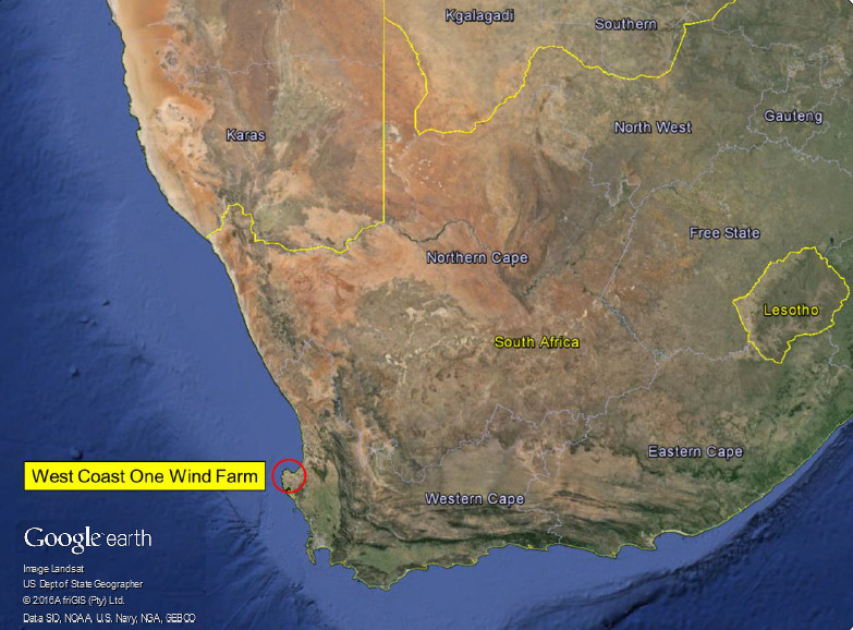
Figure 1: West Coast One Wind Farm location
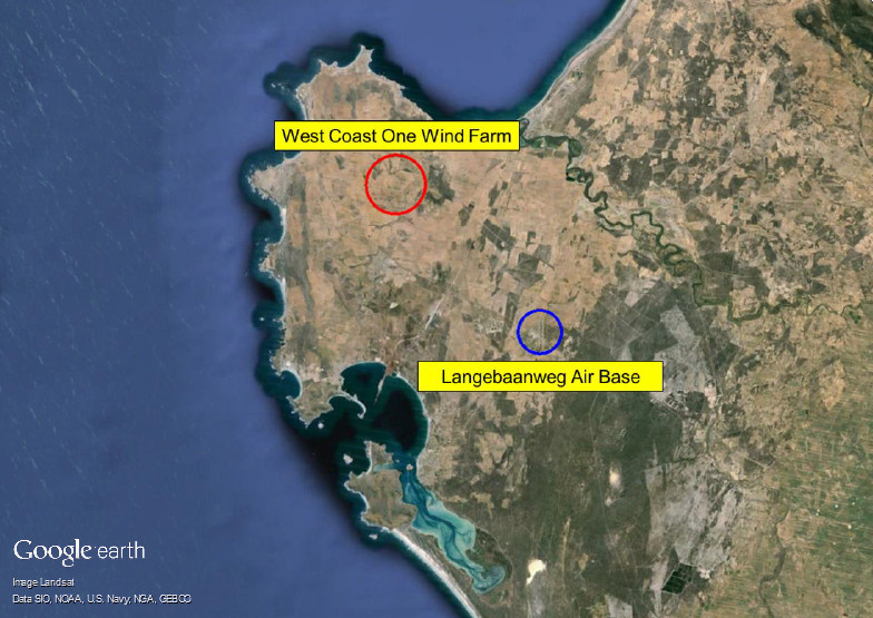
Figure 2: Wind Farm and air base locations
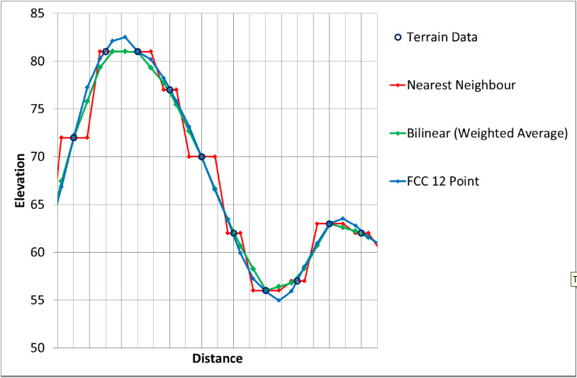
Figure 3: Terrain interpolation algorithms
How can we help you today?


THE SECTORS WE SERVE


LATEST TWEETS
Today is #EarthDay! 🌎
For the 54th edition of Earth Day, the organisation has announced its commitment towards a 60% reduction in fossil-fuel plastic production by 2040, with the 2024 theme, #PlanetvsPlastics . Learn more:
#earthday2024
The UK government is set to review glare impacts from car headlamps. We consider what this means and look at how glare impacts are handled in a wider context from various sources. Learn more: https://www.pagerpower.com/news/uk-government-to-review-headlamp-glare/
#aviationsafety #driversafety
This month in our Back to Basics series, we uncover the ways in which energy generated by wind and solar farms can be stored and how this technology will shape the future of our energy systems. Learn more: https://www.pagerpower.com/news/back-to-basics-part-4-energy-storage/
#energystorage